


1. INTRODUCTION
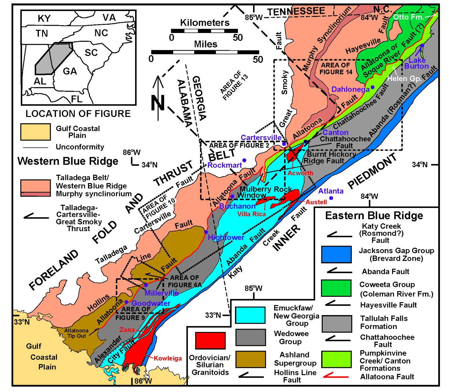
In the southern and central parts of the Appalachian orogen, the culminating tectonic events which completed the assembly of Pangea and closure of the Rheic ocean occurred during the latest Paleozoic Alleghanian orogeny that marks the collision of Laurentia with northwest Gondwana (western South America and Africa) (Bird & Dewey, 1970; Hatcher et al., 1989; Nance et al., 2010; Wilson, 1966; Ziegler, 1989). On the west flank of the orogen during this time, craton-directed thrusts and other structures developed in the southern Appalachian hinterland and foreland. These thrusts telescoped the outer margin of Laurentian cover rocks, as well as more oceanward volcanic arc and back-arc sequences and displaced them significant distances toward and across the cratonal margin. This thrust telescoping significantly shortened the Laurentian outer margin (>150%), placing higher grade metamorphic rocks on lower grade rocks, and cutting obliquely through earlier metamorphic isograds and fabrics, and lithostratigraphy. This study focuses upon the geometry and kinematic relationships of the Allatoona fault, a major regional thrust fault at the base of a distinctive metamorphic allochthon, the Dahlonega gold belt (DGB), along the northwest flank of the southern Appalachian hinterland, which developed during the final contractional stage of continental collision. This fault is internal to the Appalachian Blue Ridge-Piedmont megathrust sheet, which has been described as one of the world’s largest thrust sheets, with a minimum horizontal displacement of >350 km (Hatcher & Hooper, 1992). This nearly linear fault, extends for >280 km along the northwest flank of the Appalachian hinterland, and marks a significant change in the regional structural architecture of the orogen (fig. 1). It trends between N47°E and N 55°E (047º–055º), and deviates from linearity anywhere along its trace by less than ten kilometers. Northwest of the fault trace, distinctive orogenic curvature involving several thrust sheets is common at a variety of scales (Tull, 1984; Tull & Holm, 2005), and earlier faults have been folded by regional folds that cause significant strike changes in the faults’ traces. Southeast of the Allatoona fault, the main mass of the eastern Blue Ridge forms a linear belt, and the width (28–38 km) of that feature remains nearly constant for >400 km between the Allatoona fault and the frontal fault (for example, Abanda fault) of the Brevard zone to the southeast (fig. 1). This study demonstrates that the >280 km-long segment of the fault between its apparent tip out just north of the Gulf Coastal Plain onlap in Alabama (AL), to northeast of Dahlonega, Georgia (GA) post-dates the regional metamorphic peak and is the latest thrust in the Alleghanian kinematic sequence along the west flank of the southernmost segment of the orogen. Northeast of Dahlonega the continuation of this fault has not been resolved. The southwestern portion of the fault in AL is an internal eastern Blue Ridge fault, whereas the central 160 km-long segment of the fault trace marks the western/eastern Blue Ridge boundary, originally thought to be a terrane boundary (McConnell & Costello, 1980; Settles, 2002). This segment of the fault resulted in large-scale northwest displacement of previously deformed and metamorphosed sequences over native Laurentian sequences that formed along the Laurentian craton’s outer platform margin. The latter rocks now comprise the unmetamorphosed to anchimetamorphosed southern Appalachian foreland fold and thrust belt, and the more distal parts of that margin in the overlying Talladega-western Blue Ridge allochthon. Although the Allatoona allochthon can be classified as a “thin-skinned” thrust sheet based upon its structural thickness and lateral dimensions, its mechanical behavior significantly contrasts with the common understanding and modeling of foreland “thin-skinned” thrust sheets. In contrast to the latter, crystalline “thin-skinned” thrust sheets like the Allatoona allochthon, were internally strong, mechanically homogeneous, rigid slabs of intact cover sequences that had been previously metamorphosed and complexly polydeformed during earlier Alleghanian orogenic pulses.

2. INSIGHTS FROM THE MULBERRY ROCK WINDOW IN NORTHWEST GEORGIA
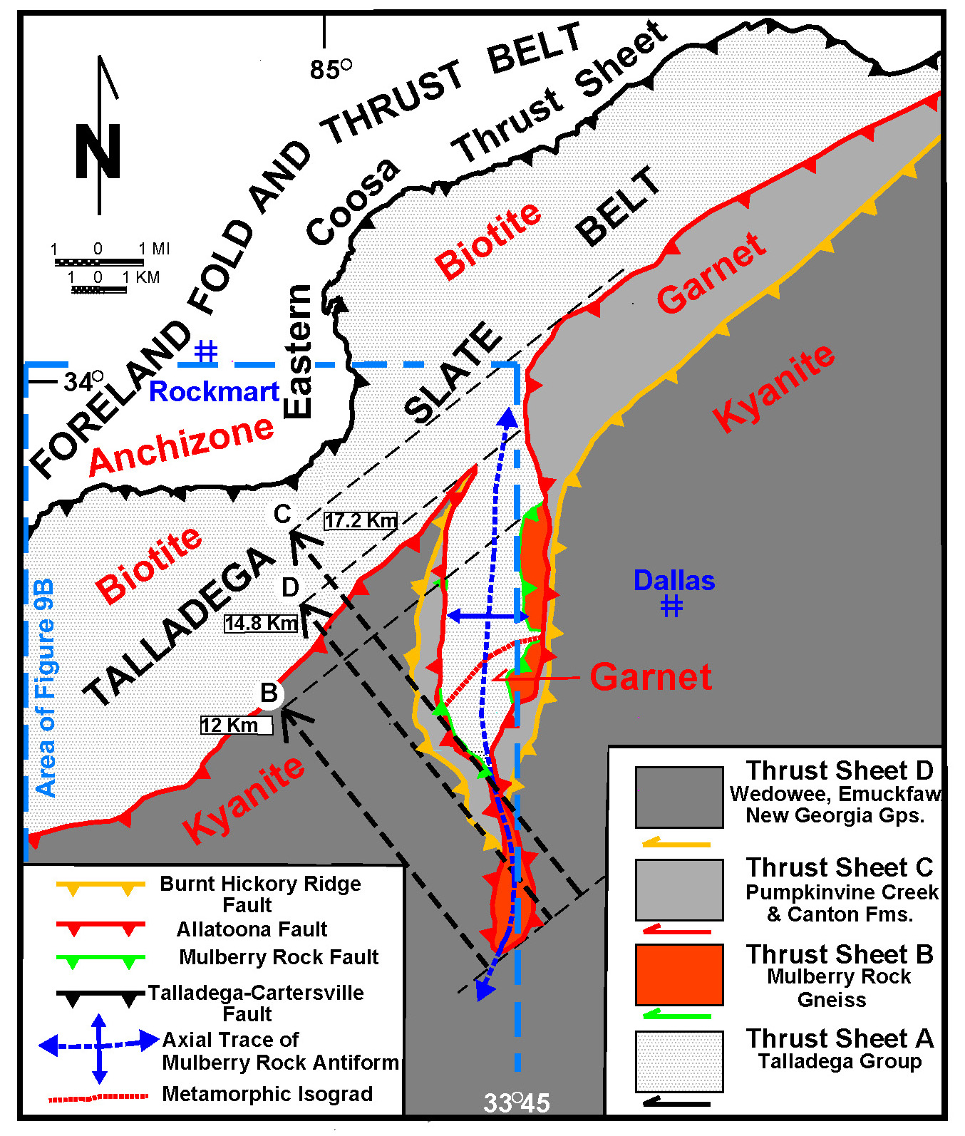
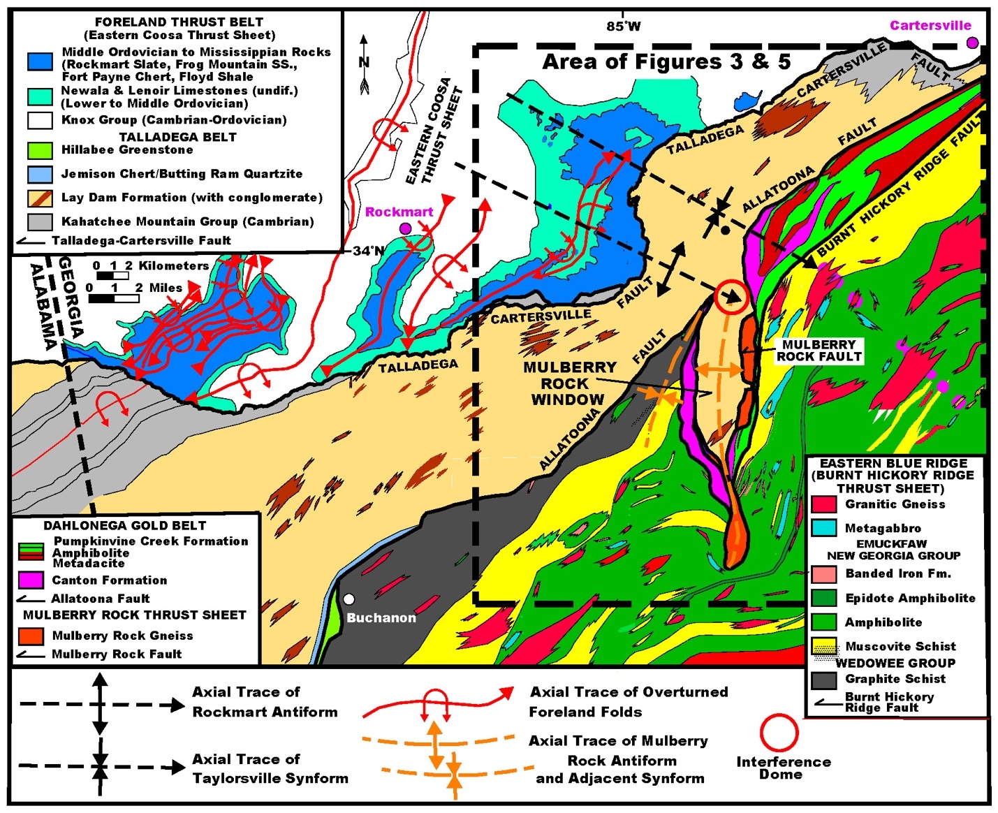
We begin discussion of the regional Allatoona fault relationships within the central segment of the fault in GA, where a breached eyelid window (a window framed by more than one thrust fault; Boyer & Elliott, 1982; Oriel, 1950) allows for three-dimensional examination of the thrust geometries and minimum displacement estimates. In northwest GA, the Mulberry Rock window forms a 20 km-long, north-south indentation into the eastern Blue Ridge-western Blue Ridge boundary between Laurentian cratonal sequences and more external Ordovician back-arc basin units (figs. 1 and 2) (Almuntshry, 2020; Holm-Denoma, 2006). This breached eyelid window occupies an area of ~65 km2, and corresponds with a gentle, upright, doubly plunging, approximately north-south-trending antiform (Mulberry Rock antiform). The core and northwest flank of the window are occupied by biotite and garnet-grade metasedimentary rocks of the Talladega belt Silurian (?)-Lower Devonian Lay Dam Formation, which consists predominantly of locally graphitic, biotite-bearing (garnet in the southern part of the window) chlorite sericite phyllite, with lenses (up to ~100 m thick) of metagraywacke and metaconglomerate (fig. 2). Parts of three eastern Blue Ridge thrust sheets are exposed around the flanks of the window above the Talladega belt footwall (western Blue Ridge), indicating that the window is a breached eyelid window (fig. 2). Thrusts bounding the allochthons surrounding the window include in ascending order: the Mulberry Rock, Allatoona, and Burnt Hickory Ridge faults, and are discussed below. Analysis of the structural framework and geological relationships of this complex structure provide important insights into the kinematics and trajectories of the regional thrusts, and a better understanding of the subsurface structure of the region in which only structurally higher levels are exposed. Thus, it is critical to our knowledge of how the frontal metamorphic allochthons were assembled.
2.1. Mulberry Rock Thrust
The Mulberry Rock Gneiss (Holm-Denoma, 2006; McConnell & Abrams, 1984) occurs structurally above rocks of the Talladega belt along the Mulberry Rock thrust, forming a thin (up to ~300 m thick) horse (or horses) discontinuously along the inner rim of the Mulberry Rock window, and locally occupying a structural position along the interface between the distinctively separate tectonic entities of the eastern and western Blue Ridge (fig. 2). The gneiss, which is only found within the confines of the window and is the only lithology within this thrust sheet, is a medium-grained, slightly metaluminous, garnet-bearing two-mica granitic gneiss (Holm-Denoma, 2006). It contains an amphibolite facies gneissosity that is cut by the surrounding faults. Laser ablation ICPMS and ion microprobe (SHRIMP) zircon U/Pb systematics of the gneiss are complicated, but the most concordant analyses are between 450 and 432 Ma (P.E. Mueller and R. Das, written communication). The gneiss is similar in age and geochemical character to other metaplutonic rocks found in the overlying Burnt Hickory Ridge thrust sheet, suggesting that it may share a genetic origin with rocks in that thrust sheet (see following). These metaplutonic rocks include the ca. 440–430 Ma Austell Gneiss (Higgins et al., 1997), the 458 ± 3 Ma Villa Rica Gneiss (C. Thomas, 2001), the 463 ± 4 Ma Acworth Gneiss (Barineau et al., 2015) in northwest GA, and the 452–435 Ma Kowaliga Gneiss and 459–430 Zana Granite in AL (Barineau et al., 2022; Sagul, 2016; Sagul et al., 2017) (fig. 1). These plutonic bodies contain inherited Grenville-age (~1.1 Ga) zircons and zircon cores, suggesting that they formed while incorporating or intruding into Laurentian-affinity, Grenvillian crust (Barineau et al., 2022; Holm-Denoma, 2006).
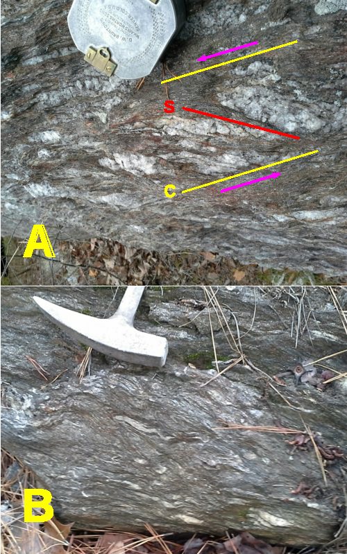
The minimal horizontal component of the net slip vector of the Mulberry Rock thrust, which separates the Mulberry Rock Gneiss from underlying rocks of the Talladega belt, is 12 km (fig. 3). The fault is a 1–2 m wide zone of intensely sheared micaceous phyllonitic footwall rocks displaying a well-developed composite planar (S-C) fabric (fig. 4A and B), and consists of intensely crenulated graphitic muscovite-chlorite schist/phyllonite. The intensely crenulated muscovite-chlorite microlithons are totally disrupted and separated by sharp, discrete parting C-surfaces, along which graphite, hematite, and very fine-grained muscovite are concentrated. The limbs of the crenulation folds are displaced by S-C shear bands and cannot be traced into adjacent crenulation folds (microlithons). The fault zone is also characterized by dismembered quartz veins that were apparently injected during a period of dilatancy as the fault developed (fig. 4).
_differentiating_the_.jpg)

2.2. Allatoona Fault
Around the flanks of the Mulberry Rock window (figs. 2 and 3), the Pumpkinvine Creek and Canton Formations of the DGB (German, 1985, 1989) lie structurally above both the Talladega belt and Mulberry Rock Gneiss along the Allatoona fault, forming a fault-bounded sequence locally as much as 3–6 km wide, with a maximum structural thickness of ~4 km. The Allatoona fault was first recognized by Crickmay (1952) at Allatoona, GA, 20 km northeast of the window, and named by Hurst (1973), who interpreted it as a thrust fault. Northeast of the Mulberry Rock window, the Talladega belt extends through the narrow constriction south of Cartersville, GA (N34°06′ latitude) into the western Blue Ridge, where at least part of the Talladega belt stratigraphy continues into the Murphy synclinorium (fig. 1) (Lupo et al., 2020; Tull & Holm, 2005). From the northeast corner of the window, for ~80 km northeastward, the Allatoona fault marks the structurally upper (southeast) boundary of both the Talladega belt and the contiguous western Blue Ridge, before crossing into the junction between the western and eastern Blue Ridge 10 km west of Dahlonega, GA (fig. 1). Although this fault is in the same structural position (constituting the eastern-western Blue Ridge boundary) as the Hollins Line thrust in AL (Tull, 1984), and the Hayesville fault in north GA (Settles, 2002) (fig. 1), it is a separate younger fault.
The Pumpkinvine Creek and Canton Formations are not exposed to the southwest beyond the northwest corner of the Mulberry Rock window, but they continue for >244 km to the northeast as the Helen Group in the DGB in north GA and the correlative Otto Formation as far northeast as southeast of Waynesville, NC (see following) (Gillon, 1982; Hatcher, 1987, 1988). The Pumpkinvine Creek Formation is a bimodal metavolcanic sequence consisting predominantly of amphibolite (metabasalt) interlayered with subordinate felsic gneiss (metadacite), in addition to minor ferruginous quartzite and garnetiferous quartzose two-mica schist (Holm-Denoma, 2006; Holm-Denoma & Das, 2010; McConnell, 1980). The informally designated Galts Ferry (McConnell, 1980) and correlative Barlow (German, 1985, 1989) gneiss members yield consistent Middle Ordovician U/Pb zircon ages (Holm-Denoma & Das, 2010; C. Thomas, 2001), and trace element and isotopic geochemistry from intercalated amphibolite suggest development in a suprasubduction setting of a back-arc basin (German, 1985; Holm-Denoma, 2006; Holm-Denoma & Das, 2010). In stratigraphic contact with the Pumpkinvine Creek Formation, metasedimentary rocks of the Canton Formation are dominated by variably graphitic, garnetiferous two-mica schist (metapelite), but also include subordinate biotite plagioclase quartz gneiss (metagraywacke) and amphibolite (German, 1985; Holm-Denoma, 2006; Holm-Denoma & Das, 2010; McConnell & Abrams, 1984). In the region of the Mulberry Rock window, the entire sequence is at garnet grade, below the kyanite isograd (fig. 3). Eighty percent of a suite of detrital zircons derived from a metasandstone within the Canton Formation yield ages between 1,190 Ma and 1,017 Ma (Holm-Denoma & Das, 2010). Two analyses, one each at 589 Ma and 513 Ma, are potentially related to synrift (Iapetan rifting) igneous rocks, and older age peaks of 1,582 Ma and 1,441 Ma correspond to ages of the Eastern Granite-Rhyolite Province (Bickford et al., 2015). All of these ages are typical of crustal materials formed during the Mesoproterozoic-Cambrian evolution of the southern and eastern margins of Laurentia and likely represent sediment derived from those regions (Bickford et al., 2015; Bream et al., 2004).
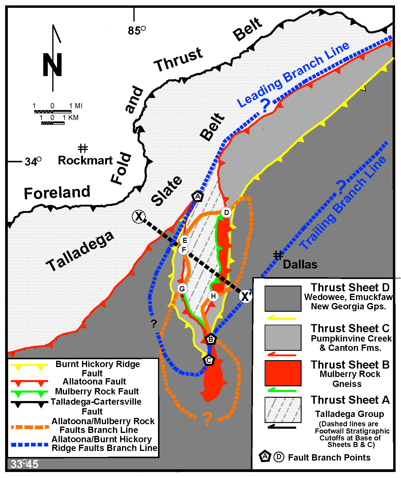
Inside the Mulberry Rock window, the footwall of the Allatoona fault is locally the Mulberry Rock Gneiss rather than rocks of the Talladega belt. Within the window, there are five branch points (points D-H, fig. 5) where the branch line marking the intersection of where the Allatoona thrust has cut structurally downward across the Mulberry Rock thrust to rest directly on the Talladega belt. These branch points can be connected either above or below ground surface to outline the branch line (orange solid and dashed lines respectively) marking the geographic limits of the Mulberry Rock Gneiss thrust sheet (fig. 5). The approximate north-south orientation of the branch line defined by the array of branch points demonstrates that the Mulberry Rock Gneiss is a large north-south horse beneath the Allatoona fault that is essentially centered on the window. In the core of the window, trendlines (stratigraphic cutoff lines beneath the overlying faults-Mulberry Rock and Allatoona) of parallel bedding and slaty cleavage within the footwall Talladega belt trend ~N25°E (025°), oblique to the window (fig. 5). These stratigraphic cutoff lines demonstrate that, from the southern to the northern end of the window, the Mulberry Rock and Allatoona faults cut toward the northwest essentially horizontally in the direction of displacement for >11 km, obliquely across (down section) rocks of the previously metamorphosed and deformed, moderately dipping Talladega belt Lay Dam Formation. The minimum horizontal component of the net slip vector of the Allatoona fault is 17.2 km, as measured from the southern tip of the window to the northwest flank of the window (fig. 3).
In the southernmost part of the window, and along its trace to the southwest of the window, immediate hanging-wall rocks of the Allatoona fault are part of the Ordovician Wedowee and Emuckfaw-New Georgia Groups described below (figs. 2 and 3). These relationships indicate that south and southwest of the window, the Allatoona fault cuts up through an earlier emplaced thrust fault (the Burnt Hickory Ridge thrust- see following) into higher grade rocks of the Wedowee, Emuckfaw and equivalent New Georgia Groups in the hanging wall of that earlier thrust and has left the Pumpkinvine Creek and Canton Formations behind (down-dip) in its footwall. At the time the Allatoona fault was active, the previously emplaced Burnt Hickory Ridge thrust (yellow line, fig. 5) was moved passively (piggy-back) as a part of the composite Allatoona allochthon. Figure 5 outlines the branch line (blue line) along which the Allatoona fault has cut up through the Burnt Hickory Ridge thrust and carries the Wedowee-Emuckfaw-New Georgia Groups in its immediate hanging wall. At two locations in the southern part of the window the Allatoona fault cuts across the Burnt Hickory Ridge fault (branch points B and C, fig. 5). South of these branch points, the Pumpkinvine Creek-Canton sheet is eliminated down dip to the southeast between the Mulberry Rock Gneiss and the overlying major eastern Blue Ridge allochthon containing the Wedowee-Emuckfaw-New Georgia Groups. This relationship also demonstrates that down dip, the Allatoona fault cuts up section in the Wedowee-Emuckfaw-New Georgia Groups. Although the Pumpkinvine Creek-Canton Formations thrust sheet (DGB) extends along strike to the northeast from the window for >244 km, at least as far as western North Carolina (NC) (Hatcher, 1987, 1988) (fig. 1), it is not found to the southwest beyond the latitude of the window. There are three branch points (A–C, fig. 5) where the branch line of intersection between the Allatoona and Burnt Hickory Ridge faults intersects the present erosion surface. On the concave side of the blue line (fig. 5), the Pumpkinvine Creek and Canton Formations make up the hanging wall of the Allatoona fault. On the convex side of that line the Allatoona fault has cut up through the Burnt Hickory Ridge fault across an oblique ramp centered on the Mulberry Rock window and contains the Wedowee-Emuckfaw-New Georgia Groups in its immediate hanging wall, and the Pumpkinvine Creek and Canton Formations have been eliminated from its footwall. On the concave side of the branch line the Allatoona fault has the Pumpkinvine Creek-Canton Formations in its immediate hanging wall. Southwest of these locations, the Allatoona fault carries the Wedowee and Emuckfaw-New Georgia Groups thrust sheet directly over rocks of the Talladega belt, implying that southwest of the window, the Allatoona fault has cut up through the Pumpkinvine Creek and Canton Formations, eliminating them farther to the southwest, and has cut off the older Burnt Hickory Ridge fault in its hanging wall, becoming the structural base of the Wedowee and Emuckfaw-New Georgia Groups thrust sheet as it extends southwestward toward AL. In addition, the Mulberry Rock Gneiss appears to have been eliminated to the southwest of the window (see previous) (fig. 5). The blue dashed line northeast of point A (fig. 5) is the projected branch line above the present erosional surface and suggests that, like the Mulberry Rock Gneiss, the Pumpkinvine-Canton Formations thrust sheet (DGB) is a large horse embedded along the Talladega belt-eastern Blue Ridge boundary, which terminates along an oblique ramp at the Mulberry Rock window (see following).

2.3. Burnt Hickory Ridge Thrust
The Burnt Hickory Ridge fault (figs. 2 and 5) is the structurally highest fault associated with the Mulberry Rock window. Along both flanks of the window, and to the northeast of the north portion of the window, rocks of the Wedowee or stratigraphically overlying Emuckfaw-New Georgia Groups are faulted above the Pumpkinvine Creek and Canton Formations along this thrust (fig. 2). This fault displays a number of characteristics similar to that of the Hollins Line fault in AL at the base of the eastern Blue Ridge allochthon (fig. 1) (Tull, 1984). For example, it occurs at a similar position in the regional kinematic sequence, it carries the stratigraphy of the major eastern Blue Ridge allochthon (Wedowee and Emuckfaw-New Georgia Groups) in its hanging wall, and its trajectory is semi-concordant to Ordovician metavolcanic rocks (Pumpkinvine Creek Formation) in its footwall, but it is highly discordant to the high grade metamorphic units of the major eastern Blue Ridge allochthon within its hanging wall (fig. 6). Like the Hollins Line fault (fig. 6A), it cuts down section stratigraphically to the northwest in the hanging wall in the direction of displacement, obliquely through the metamorphic fabrics, and significantly, through >7 km of the lithostratigraphy within the Wedowee and Emuckfaw-New Georgia Groups (figs. 2 and 6B). Correlation of the Hollins Line and Burnt Hickory Ridge faults would also indicate that, in addition to cutting down section to the northwest in the hanging wall, the thrust also cuts down section in the hanging wall to the southwest. On the east flank of the Mulberry Rock window, the Burnt Hickory Ridge thrust has cut all the way up into the Emuckfaw-New Georgia Groups, whereas ~50 km to the southwest, the Hollins Line fault occurs near the base of the Ashland Supergroup (figs. 1 and 2), as much as 10 km beneath the stratigraphic level at the window. This implies a significant rise in the stratigraphic level of this thrust to the northeast. The immediate footwall of this thrust system, however, is essentially confined everywhere to within a 2.6-4 km-thick section of Ordovician bimodal metavolcanic rocks and associated metasediments along a strike distance of >200 km. To the southwest, the immediate footwall is the Ordovician Hillabee Greenstone (fig. 6A) (Tull et al., 2007), whereas to the northeast in the vicinity of the Mulberry Rock window, the immediate footwall is the Pumpkinvine Creek-Canton Formations (fig. 6B) which are potentially correlative with the Hillabee Greenstone (Holm-Denoma & Das, 2010; McConnell, 1980). The geometry within the Mulberry Rock window indicates that the minimum horizontal component of net slip on the Burnt Hickory Ridge fault is 14.8 km, as it displaced the Wedowee and Emuckfaw-New Georgia Groups to the northwest over the Pumpkinvine Creek and Canton Formations (fig. 3).
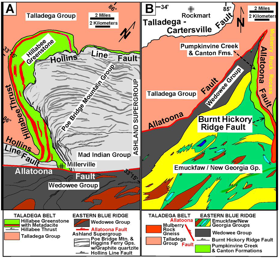
Several authors have suggested a potential genetic relationship between the Pumpkinvine Creek Formation and the Hillabee Greenstone, which occur directly along strike from one another (Holm-Denoma & Das, 2010; McConnell, 1980). Both units consist of bimodal sequences of metabasalt and interstratified metarhyolite/metadacite, and they are of similar age (460– 470 Ma). Chemically, both sequences exhibit back-arc suprasubduction zone signatures (Holm-Denoma, 2006; Holm-Denoma & Das, 2010; McClellan et al., 2007; McConnell, 1980; Tull et al., 1998, 2007). Although both units are of similar thickness (~2.6 to 4 km), occur along the boundary between the Talladega belt–western Blue Ridge allochthon and rocks of the eastern Blue Ridge, and are tectonically bounded both above and below, they are separated along strike by a gap of ~25 km (fig. 2) and are at different metamorphic grades (amphibolite and greenschist facies, respectively). Careful examination of the structural kinematics of these sequences, however, shows a marked difference in their current structural positions. The dominantly lower greenschist facies Hillabee Greenstone was emplaced along the Hillabee thrust, which is the earliest fault in the kinematic sequence (Tull et al., 2007), whereas the garnet-grade Pumpkinvine Creek and Canton Formations were emplaced along the Allatoona fault, which is the latest fault in the regional kinematic sequence. Nevertheless, because of their unique similarities in age and composition, and the fact that they each formed in similar suprasubduction zone back-arc environments, the Hillabee and Pumpkinvine formations were probably originally part of the same volcanic basin, but were tectonically decoupled prior to accretion, as indicated by their current structural positions and metamorphic grade.
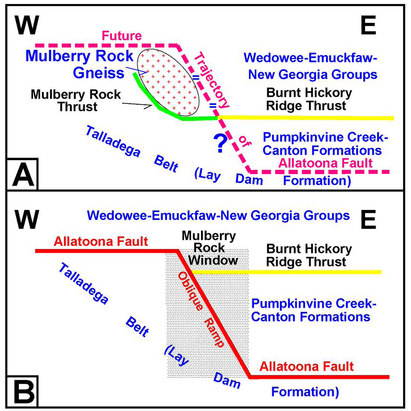
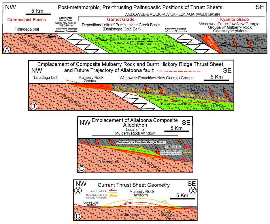
The structural position of the thrust sheet containing the Mulberry Rock Gneiss is odd because neither of its bounding thrust sheets (Talladega belt and Dahlonega thrust sheets, fig. 5), contains plutonic rocks. As noted previously, however, the Burnt Hickory Ridge thrust sheet contains numerous plutonic bodies of similar age, size, and composition to the Mulberry Rock Gneiss. A likely possibility is that the Mulberry Rock Gneiss was originally a large (>65 km2) plutonic component of the Burnt Hickory Ridge thrust sheet, located along the northwest margin of that structure (fig. 7A and B). If so, then the Burnt Hickory Ridge fault must have initially displaced the composite sheet containing the Mulberry Rock Gneiss and the Wedowee and Emuckfaw-New Georgia Groups structurally over the location of the previously deformed and metamorphosed Pumpkinvine Creek/Canton basin rocks, and then upward onto rocks of the Talladega belt along the outer Laurentian shelf (fig. 7B), because the Mulberry Rock Gneiss lies directly atop Talladega belt rocks all along the Mulberry Rock fault on the inner flanks of the window (figs. 2 and 3). The same relationship can be observed at the northwest corner of the window at point “A” in figure 5, where the Burnt Hickory Ridge thrust also was at least locally emplaced against rocks of the Talladega belt. This scenario suggests that the Mulberry Rock and the Burnt Hickory Ridge faults were originally the same structure (fig. 7A and B) but were later cut by the younger Allatoona fault, with the Mulberry Rock Gneiss left as an isolated horse(s) in the footwall of the latter fault, and the Wedowee and Emuckfaw-New Georgia Groups and the Burnt Hickory Ridge fault later carried forward passively in a piggy-back fashion above the Allatoona fault (fig. 7C and D). The minimum horizontal component of net slip on the Mulberry Rock fault is ~12 km in a northwest direction (fig. 3), as it displaced the Mulberry Rock Gneiss over the Talladega belt. If the Mulberry Rock and the Burnt Hickory Ridge faults were originally the same fault, as suggested here, then the minimum horizontal component of net slip on it would be the sum of these two faults, or ~27 km. Fifty kilometers northeast of the Mulberry Rock window, southeast of Canton, GA, the Burnt Hickory Ridge fault merges with the overlying Chattahoochee fault (fig. 1). The relative ages of these two faults are currently unknown, although the Chattahoochee fault hanging wall contains a higher-grade rock assemblage than those in the Burnt Hickory Ridge fault hanging wall.
2.4 Mulberry Rock Antiform
The dominant structural feature of the Mulberry Rock window is a gentle, upright, shallowly doubly plunging antiform (Mulberry Rock antiform) with an axial trace trending ~ N 04° E (04°) (fig. 2). Erosional breaching of this antiform resulted in exposure of the structural framework of the eyelid window (described above) at the current erosional level. The antiform is an enigmatic structure both because of its anomalous orientation relative to other structures in the region, and because the Talladega belt rocks in the core of the antiform do not appear to have been folded by the antiform, whereas the thrust sheets on its flanks have been broadly flexed across it. To assess the geometry of the antiform, the region was divided into nine subareas for structural analysis, consisting of portions of individual thrust sheets inside, outside, and on each limb of the antiform (Almuntshry, 2020; Tull et al., 2017). Planar fabrics (compositional layering and cleavage/schistosity/gneissosity), which predate thrusting within the individual thrust sheets, mostly strike northeast and dip moderately to steeply to the southeast, oblique to the approximately north-south trend of the antiform axis. Although the axis of the subhorizontal antiform is 35°–45° oblique to the strike of compositional layering and cleavage/schistosity/gneissosity within the various thrust sheets, progressive tightening (increasing limb dips) of the antiform should rotate these planar data on the west limb westward, resulting in shallower southeast dips and more easterly strikes than the original regional orientation, and should rotate planar fabrics on the east limb eastward, resulting in steeper southeast dips and more northerly strikes than the regional orientation on that limb. For the Talladega belt (Lay Dam Formation), this analysis illustrates that there is essentially no difference (no rotation) in subparallel slaty cleavage and bedding orientations both inside and outside of the window, or on either side of the antiform axial trace within the window. Cleavage and bedding on each side of the axial trace inside of the window in the Talladega belt have essentially the same orientation and show no noticeable relative rotation as a result of formation of the antiform (Almuntshry, 2020; Tull et al., 2017), that is, the bedding and slaty cleavage within the Lay Dam Formation pass undeflected across the axial trace of the antiform. In contrast however, planar fabrics in the Pumpkinvine Creek-Canton thrust sheet and the overlying Wedowee-Emuckfaw-New Georgia thrust sheet on each limb of the antiform show a slight rotation of 10°–15°, with those on the west limb having a shallower average dip and more easterly strike than those on the east limb, whereas those fabrics in each thrust sheet on the east limb show an increase in dip and a more northerly strike than those on the west limb (Almuntshry, 2020; Tull et al., 2017). We interpret these relationships to indicate that the Mulberry Rock antiform is a very gentle fold with a large interlimb angle of ≥140° that has arched the initially southeast-dipping thrusts into the current geometry of the antiform. Because of the large interlimb angle, the antiform is a very subtle structure, with cleavage/schistosity/gneissosity on each limb dipping toward the southeast. A fold with increased tightness such as an open fold (interlimb angle 120° to 70°) or tighter would significantly change the orientations of cleavage/schistosity/gneissosity on each limb of the antiform relative to the other, but this is not the case.
Importantly, as noted above, the antiform is sited directly above the large, north-south oriented thrust horse of the massive Mulberry Rock Gneiss (fig. 5). Around the rims of the window, the Allatoona fault has displaced its hanging wall rocks above the gneiss. In the southern portion of the window and beyond the west rim of the window, the Allatoona fault has ramped upward through the Burnt Hickory Ridge fault, such that the Wedowee and Emuckfaw-New Georgia Groups are in its immediate hanging wall (see previous and fig. 5). The branch line between the Allatoona and Burnt Hickory Ridge faults in the southern part of the window (line B-C, fig. 5) is oriented ~N5°E (005°), parallel to the axial trace of the antiform. All of these relationships suggest that the Mulberry Rock antiform is the result of an oblique ramp in the Allatoona fault as its trajectory encountered the massive Mulberry Rock Gneiss in its footwall, and the thrust ramped upward toward the west across the Burnt Hickory Ridge thrust, into the Wedowee and Emuckfaw-New Georgia Groups thrust sheet, broadly arching the composite allochthon across the ramp and producing the open Mulberry Rock antiform (figs. 7C, 8A and B). Talladega belt rocks in the footwall of the ramp were unaffected by the flexing of the composite allochthon across the ramp.

3. REGIONAL ALLATOONA FAULT FOOTWALL RELATIONSHIPS
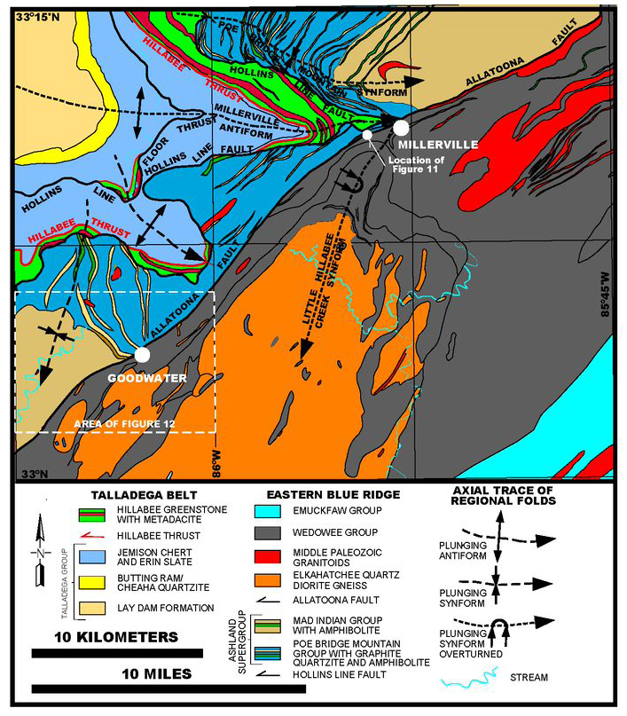
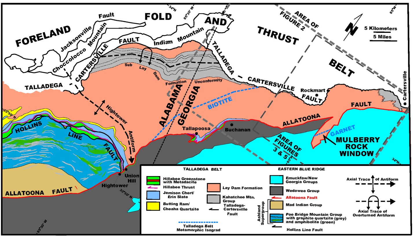
Fifty-eight km southwest of the Mulberry Rock window at Hightower, AL, the Allatoona fault becomes an internal eastern Blue Ridge fault, and 108 km farther southwest, southwest of Goodwater, the Allatoona fault apparently tips out, and the boundary between the Wedowee Group and the Ashland Supergroup is interpreted as a polydeformed premetamorphic stratigraphic contact (fig. 1) (Allison, 1992). Along its northeast trace, from Goodwater, for ~5 km northeastward, the fault trends almost perpendicular to, and abruptly truncates the structurally underlying south-southeast-trending units of graphitic quartzite and amphibolite in the Higgins Ferry Group of the Ashland Supergroup (fig. 9). At this latitude, the Allatoona fault is >6 km structurally above the Talladega-Cartersville fault, but along its trace 120 km to the northeast to Cartersville, GA, it progressively cuts structurally downward through the underlying tectonostratigraphy (including the structurally underlying Hollins Line and Hillabee thrust faults) to approach within <200 m of the Talladega-Cartersville fault (fig. 1). Northeast of Goodwater, in its footwall near Millerville, AL, the Allatoona fault decapitated regional cross folds of the Millerville-Childersburg generation (Tull, 1984), including the Millerville antiform and Poe Bridge Mountain synform, and approaches within 400 m of the trace of the older Hollins Line fault, essentially isolating the Ashland Supergroup into two regional salients (figs. 1 and 9). The fault also decapitated a map-scale antiform northeast of Goodwater which folds the Hollins Line thrust system (fig. 9). Farther northeast at Hightower, AL (fig. 10), the Allatoona fault decapitated another regional cross fold (Hightower antiform) of the Millerville-Childersburg generation in its footwall, and it cuts the older Hollins Line and Hillabee thrusts at a high angle. Here, the Hightower antiform plunges 20° S19° E (161º) (Mies, 1992), but as the fold is traced to the northwest, its trace curves to a more east-west orientation. In addition to folding the Hollins line fault system, the Millerville and Hightower antiforms also fold the underlying Hillabee thrust, the Talladega-Cartersville fault, and several underlying thrust sheets in the southeastern foreland, including some which contain Pennsylvanian strata (Brewer, 2004), indicating that these cross folds are Late Carboniferous or younger. Because of its cutoff at Hightower by the Allatoona fault, the distinctive sequence of the Ashland Supergroup (Tull, 1978), which forms the hanging wall of the Hollins Line fault (fig. 1), is never exposed again to the northeast. In an alternative interpretation, Mies (1992) suggested that the Hollins Line and Allatoona faults were the same fault that had been folded around the Hightower antiform. Although he showed no fault to the southwest of Hightower, other geologists (for example McClellan et al., 2007; Osborne et al., 1988; Tull, 1978; Tull et al., 1993) extend a fault, previously referred to as the Goodwater-Enitachopco fault, from the southwest through Hightower, to where it links up with the Allatoona fault extending southwest from GA. In Mies’ (1992) interpretation, rocks of the Poe Bridge Mountain Group are folded around the hinge of the Hightower antiform, and on the east limb of that structure are equivalent to what we have traced continuously from the southwest as the Wedowee Group. Although they both contain graphitic schist, these are distinctively different lithologic sequences. The latter group is separated from the former group by several kilometers of stratigraphy in the Mad Indian Group (fig. 10). Unfortunately, Mies (1992) shows no map data in a critical ~82 km area encompassing the fold hinge required to demonstrate stratigraphic continuity between the two limbs of the Hightower antiform and to demonstrate that the Hollins Line and Allatoona are the same fault. The cutoff of the stratigraphic contact between the Mad Indian Group and the Poe Bridge Mountain Group by the Allatoona fault against the Wedowee Group occurs to the southwest of Hightower (fig. 10).


For ~125 km, from the northwest flank of the Mulberry Rock window to the southwest tip out of the fault in AL, the Allatoona fault marks the northwest boundary of the Wedowee Group in the hanging wall, but the immediate footwall is marked by a number of stratigraphic units and decapitated structures. Although exposures of the Allatoona fault are rare, from all of our observations along the fault trace, it appears that the actual fault zone is very narrow, no thicker than 10-20 m. Southwest of Hightower the Allatoona fault (previously referred to as the Goodwater-Enitachopco fault, Tull, 1978) has imbricated rocks of the eastern Blue Ridge and is an internal eastern Blue Ridge fault that has the Ashland Supergroup in its immediate footwall, and the Wedowee Group in its hanging wall, but to the northeast it has rocks of the Talladega belt/western Blue Ridge in its immediate footwall and becomes the western-eastern Blue Ridge boundary (figs. 1 and 10).
_oblique_view_toward_the_south_southwest_(__55_from_strike_of_fault)_of_vertical_road_.jpg)
From Hightower, AL, along most of its trace northeastward for 90 km to Cartersville, GA, the immediate footwall of the Allatoona fault is at various stratigraphic levels within the Silurian(?)-Devonian Lay Dam Formation in the Talladega belt (figs. 2 and 10). There are two exceptions to this relationship: A) in down-dip segments of the fault seen along the inner flanks of the Mulberry Rock window, the Allatoona fault locally lies above a thin horse(s) of the Mulberry Rock Gneiss (see previous) (figs. 2 and 3), and B) in a small recess in the trace of the thrust between Tallapoosa and Buchanan, GA the fault has cut up section to the structural top of the Talladega belt, exposing rocks equivalent to the Devonian Butting Ram/Cheaha Quartzite and Jemison Chert, the overlying Hillabee thrust, and the Ordovician Hillabee Greenstone (figs. 2 and 10) (Heuler, 1993), similar to the relationships seen in the immediate footwall of the Hollins Line thrust to the southwest. In the second instance, near Buchanan, GA, the Allatoona fault occurs at the structural and stratigraphic top of the Lay Dam Formation, but as it is traced northeastward from Buchanan, it progressively cuts obliquely down section in its footwall into structurally and stratigraphically lower parts of that formation, such that south of Cartersville, GA, almost the entire ~2.4 km thick Lay Dam Formation has been eliminated/cut out in the footwall of the Allatoona fault (figs. 2 and 10). At Cartersville, less than ~200 m of that formation above its basal contact (sub-Lay Dam unconformity) with the Kahatchee Mountain Group passes northeastward into the western Blue Ridge (Tull & Holm, 2005), and the trajectory of the Allatoona fault cuts nearly to the structural depth of the older underlying Talladega-Cartersville fault (fig. 10). Southeast of Cartersville, the Allatoona fault decapitated the regional Cartersville cross antiform (see following) and continues cutting down section northeastward, where 25 km northeast of Cartersville, the fault has cut down into rocks of the Neoproterozic Great Smoky Group. These regional footwall relationships are similar to those seen on a smaller scale within the core of the Mulberry Rock window (see previous), and demonstrate that north of Buchanan, GA, the trajectory of the Allatoona fault is oblique to stratigraphy and structure in the underlying Talladega belt/western Blue Ridge allochthon, such that it cuts down-section through that underlying allochthon both to the northwest and northeast. Thus, the trace of the Allatoona fault, the youngest major thrust fault in the metamorphic core of the southern Appalachians, extends for >280 km from its tip out southwest of Goodwater, AL, to the junction between the western and eastern Blue Ridge allochthons west of Dahlonega, GA (fig. 1). The extension of the fault northeast of that junction is still open to debate (see following).
4. REGIONAL ALLATOONA FAULT HANGING WALL RELATIONSHIPS
At the point 11 km southwest of Goodwater, AL, where displacement on the Allatoona fault apparently tips out (Allison, 1992), the fault occurs at the base of the Wedowee Group (fig. 1). From here, northeastward, it cuts obliquely structurally upward into the polydeformed Wedowee lithostratigraphy, decapitating the Little Hillabee Creek synform in its hanging wall at Millerville (fig. 9), and eventually completely excising the entire >8 km thick Wedowee Group at the northwest corner of the Mulberry Rock window (fig. 2). Thus, in its hanging wall, the Allatoona fault cuts stratigraphically entirely through the stratigraphy of the Wedowee Group both down dip of the fault to the southeast (see relationships around the flank of the Mulberry Rock window), and along its trace northeastward. However, northeast of the window and around the flanks of the window, the fault has cut structurally downward and the immediate hanging wall consists of the Ordovician Pumpkinvine Creek and Canton Formations (see previous).
Rocks of the Wedowee Group are dominated by locally highly carbonaceous metapelite (variably garnetiferous graphitic schist) interlayered with less common quartzite and thin layers of highly feldspathic schist and/or fine-grained biotite gneiss interpreted as metagraywacke (Allison, 1992; Neathery & Reynolds, 1973). Accessory minerals include tourmaline, staurolite, kyanite, and sillimanite. The structurally and stratigraphically overlying Emuckfaw Group (Heard Group of Bentley & Neathery, 1970) in AL and the equivalent New Georgia and Sandy Springs Groups (German, 1985; McConnell & Abrams, 1984) in GA (fig. 2) consist of a sequence of variably graphitic-garnetiferous two-mica schist interlayered with less common fine-grained variably garnetiferous, biotite paragneiss (metagraywacke), micaceous quartzite, metaconglomerate, metadiamictite, and rare calc-silicate rocks, in addition to variable amounts of amphibolite. The lower contact of the Emuckfaw-New Georgia Group with the underlying Wedowee Group is commonly marked by gradation of highly graphitic schist of the Wedowee Group into non-graphitic or graphite-poor schist of the lower Emuckfaw over an interval of 5–15 m, commonly coinciding with the appearance of amphibolite in the lower Emuckfaw. Less than 20% of the Emuckfaw section in AL and westernmost GA consists of amphibolite (metabasalt), with most of the section being composed of metasedimentary rocks dominated by mica schist. However, northeastward in GA, towards the Mulberry Rock window, in the stratigraphically equivalent New Georgia Group, the volume of metabasalt increases significantly, becoming the predominant lithology (fig 2). This section is also marked by an abundance of banded iron formation and small metagabbro bodies.
U/Pb detrital zircon studies have been conducted on a number of metasedimentary units from this sequence. All of the units contain an overwhelming dominant population of Mesoproterozoic U/Pb zircon ages between 1.2 and ca. 0.9 Ga, which are typical of Laurentian crustal materials formed during the Grenville orogeny (Rodinian collision; Tollo et al., 2010), and most likely represent sediment derived from the adjacent Laurentian continental margin or exposed rifted-margin Proterozoic basement blocks (and/or their cover) along that margin (Tull et al., 2014). Older age peaks between 1.5 Ga and ca. 1.3 Ga are not uncommon and correspond to ages of the Laurentian eastern Granite-Rhyolite Province (Bickford et al., 2015). In addition to the Mesoproterozoic detrital zircons, those extracted from metasandstone and metagraywacke in the middle and upper Wedowee and lower Emuckfaw Groups also yield U-Pb ages between ca. 474 Ma and 460 Ma, suggesting a Middle Ordovician as well as a Mesoproterozoic (Grenville) source for much of the sediment within this thrust sheet (Tull et al., 2014). The presence of Middle Ordovician detrital zircons suggests proximity to Middle Ordovician igneous units of this predominantly sedimentary basin. Units of this age in the region include the metavolcanic rocks within the Pumpkinvine Creek Formation (see previous). Youngest detrital zircons from the Wedowee Group are ca. 460 Ma and provide an approximate maximum depositional age for the sequence, whereas this thrust sheet contains numerous pre-kinematic intrusive bodies of felsic gneiss that provide an upper age constraint on deposition. These include the 463 ± 4 Ma Acworth Gneiss (Barineau et al., 2015), the 458 ± 3 Ma Villa Rica Gneiss (C. Thomas, 2001), the 467–455 Ma Kowaliga Gneiss (Barineau et al., 2015, 2022; Sagul, 2016; Sagul et al., 2017), and the 477–457 Zana Granite (Barineau et al., 2015, 2022; Sagul, 2016; Sagul et al., 2017) (fig. 1).
5. SUMMARY OF REGIONAL HANGING AND FOOTWALL RELATIONSHIPS OF THE ALLATOONA FAULT
Like the two crystalline thrust sheets structurally beneath the Allatoona fault (bounded by the Talladega-Cartersville and Hollins Line faults), the Allatoona fault is out-of-sequence relative to the other major thrusts in the region. Because of this fact, along much of its trace (for example southwest of Hightower, AL and northeast of Cartersville, GA) it emplaces higher structural/stratigraphic levels upon lower ones, whereas in the central region it emplaces lower structural/stratigraphic levels upon higher ones. Both the hanging and footwall geometric relationships indicate that the Allatoona fault is oblique to lithostratigraphy, earlier structures, and metamorphic isograds along strike and down dip in both its hanging and footwalls. However, in its footwall the fault cuts structurally downward toward the northeast through the Hollins Line fault system and overlying Ashland Supergroup, the Hillabee thrust, and through almost the entire underlying Lay Dam Formation in the Talladega belt, closely approaching the Talladega-Cartersville fault at Cartersville, GA (figs. 2 and 10). In its hanging wall, it cuts structurally and stratigraphically upward toward the northeast as well as down dip, eliminating the Wedowee Group at the latitude of the Mulberry Rock window (figs. 2 and 10). Southwestward from the Mulberry Rock window it has cut up lithostratigraphically through the previously emplaced overlying eastern Blue Ridge allochthon carrying that allochthon farther forward to the northwest. Southwest of Hightower, AL, the Allatoona fault has imbricated the main eastern Blue Ridge allochthon (Ashland-Wedowee-Emuckfaw belt) and has that allochthon in both its hanging and footwalls.
6. ALLATOONA FAULT ZONE CHARACTERISTICS
Limited exposures of the Allatoona fault have resulted in limited kinematic data related to this structure. However, 1.5 km north of Hightower, at Union Hill, AL (fig. 10), Mies (1992) reported quartz crystallographic fabric studies from an escarpment formed along the Allatoona fault zone which identified asymmetric single c-axis girdles, indicating top-to-northwest movement. This is supported by a similar sense of displacement indicated by well-developed asymmetrical extensional shear band textures (S-C mylonites), σ-type porohyroclasts, and asymmetric folds at several locations in immediate hanging wall rocks along the trace of the fault where it overlies the Talladega belt between Hightower and the AL/GA border (Mies, 1992).
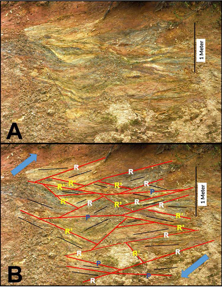
Two kilometers southwest of Millerville, AL, where the Allatoona fault is internal to the eastern Blue Ridge allochthon, the fault is exposed within an ~15 m thick zone separating hanging wall rocks of the Wedowee Group from footwall rocks of the Higgins Ferry Group (figs. 1 and 9). Here, the fault zone contains numerous thin subsidiary brittle shear zones separating fault slices (horses) of different lithology and orientation, including graphitic schist, granitic gneiss, and mafic rocks. Based upon the orientation of the subsidiary shear zones relative to each other and to the orientation of the overall fault zone, we interpret the geometry of these structures to be in the orientations of predicted brittle Riedel shears (Hills, 1963) that are subsidiary to the main thrust. We interpret the low-angle shears dipping to the (southeast) (to the left in fig. 11) to be “R” Riedel shears that develop at a small angle (typically 10–20°) to the main fault and are synthetic to the main fault. “R’” shears (fig. 11) are conjugate, or antithetic to the “R” shears, and are oriented at a high angle to the main fault plane. “P” shears (fig. 11) are synthetic minor faults symmetrically oriented relative to the R shears with respect to the main fault plane. The orientation of the array of Riedel shears indicates top to the northwest (thrust) displacement on the fault (blue arrows, fig. 11). Compositional layering and foliation within individual fault slices have various orientations as a result of differing relative rotations of the various fault slices.
The segment of the Allatoona fault southwest of Hightower was originally interpreted as a thrust (Tull, 1975, 1978). However, controversy has arisen as to the sense of displacement along this fault segment because of the recognition of a normal fault beneath the railroad bridge in Goodwater, AL (fig. 12) that was referred to for several decades as the Goodwater fault. This discovery led to the interpretation that the southern segment of the Allatoona fault (Goodwater-Enitachopco fault) was a normal fault and not a thrust (Allison, 1992; Barineau et al., 2015; Drummond, 1986; Drummond et al., 1994, 1997; Steltenpohl et al., 2013; Tull, 2011; Tull et al., 1985; Tull & Campbell, 2012). However, our recent work suggests that the normal fault in Goodwater does not correspond to the Wedowee Group/Ashland Supergroup boundary, but instead is an internal Wedowee fault with only minor displacement, and that the actual trace of the Allatoona fault is ~250 m to the northwest (see following).

In the Goodwater area, Steltenpohl et al. (2013) interpreted what they referred to as the Goodwater-Enitachopco fault to be a broad zone (>1.7 km wide) with dispersed kinematic indicators having an oblique dextral and normal slip sense. However, they based this interpretation on structural features that we do not believe to be associated with the actual Allatoona fault, which occurs at the northwest boundary (base) of the Wedowee Group in that area. Their evidence for a fault in the Goodwater area was related to what they referred to as “type 1” and “type 2” shears in the region. They described the earlier “type 1” shears as “occurring near metamorphic peak deformational conditions under upper greenschist to lower amphibolite facies (450–600 °C), being roughly coplanar with the dominant schistosity of the country rock, and producing northwest-southeast stretching lineations.” Based upon 40Ar/39Ar muscovite and hornblende cooling ages, they placed a minimum time of extensional movement along the “type 1” shears between ca. 334 and 327 Ma (Middle Mississippian). In our interpretation, however, these “type 1” shears do not have any spatial or temporal association with the narrow fault zone (Allatoona) at the structural base of the Wedowee Group in the Goodwater area. First, the dominant schistosity and compositional layering in the footwall of the fault, with which these shears are said to be “roughly coplanar,” are cut at a high angle by the fault, and therefore predate it, a relationship that can be clearly observed in the Goodwater area (fig. 12). Second, the predominantly southeast-plunging syn-metamorphic stretching lineations are pervasive for many kilometers away from the fault throughout the rocks of both structural blocks, and they have no spatial or temporal association with the fault (fig. 12). Third, Steltenpohl et al. (2013) argue that the Goodwater-Enitachopco fault formed as a normal fault synchronously with movement along both the Hollins Line fault (a major regional thrust fault) and the Millerville-Childersville generation cross-folds that fold the latter fault system (fig. 9) (Tull, 1984). As mentioned previously, the Allatoona (Goodwater-Enitachopco) fault clearly cuts (is not folded by) the regional Millerville cross antiform, which is a close fold with a <90° interlimb angle. That fold, which is Late Carboniferous or younger, not Middle Mississippian in age (see previous), like the Hightower antiform folds several underlying thrust faults to the northwest including the earlier emplaced Hollins Line and Talladega-Cartersville faults, as well as underlying thrust sheets in the foreland (Tull, 1984). Although our mapping suggests that the Allatoona fault forms a narrow fault zone only a few meters in width, Steltenpohl et al. (2013) suggested that it is “not a simple single-strand fault, as shown on earlier maps,” but rather is represented by their two types of shears which appear to be dispersed throughout both fault blocks. Although they did not indicate where most of the measurements of their “type 1” and “type 2” shears were made, based upon the two locations shown, they indicate that the fault zone is ≥1.75 km wide.
The two locations cited by Steltenpohl et al. (2013) of their type-2 shears do not correspond to where we map the narrow trace of the Allatoona fault. One occurs beneath the Goodwater railroad bridge 250 m southeast of the fault trace along the northwest margin of the Wedowee Group, and the other occurs 9 km southwest of Goodwater and 1.5 km northwest of where we map the trace of the fault (fig. 12). At each of these locations the “type-2” shears have only a few meters of displacement, unlike the Allatoona fault at the base of the Wedowee Group which clearly has many kilometers of displacement (fig. 12). Because of poor exposures in the area, it is likely that few, if any of Steltenpohl et al. (2013) reported 18 measurements of those “type-2” shears were from the actual Wedowee-Ashland contact where we place the fault. The normal fault under the Goodwater railroad bridge, described as a Goodwater-Enitachopco fault “type 2” shear, is internal to the Allatoona allochthon and to the Wedowee Group, separated from the Wedowee-Ashland contact to the northwest by a 200 m thick section of un-faulted thinly-layered Wedowee Group graphitic muscovite schist and metagraywacke. The normal fault strikes ~80° E (080°), oblique to the Allatoona fault, which strikes 60° (060°) E in Goodwater, but does not appear to offset the Allatoona or measurably offset internal Wedowee stratigraphy (fig. 12). The second example of a “type-2” shear cited by Steltenpohl et al. (2013) has only a few meters of displacement and is intruded by a synkinematic trondhjemite dike. Although we have observed a number of localities along the trace of the Allatoona fault where the fault cuts Middle Paleozoic granitoids, we have never observed a location where the opposite relationship is true. Like the “type 1” shears, Steltenpohl et al. (2013) inferred the deformational temperatures for the “type 2” shears to be beneath the ductile-brittle transition, but as opposed to the “type 1” shears, they describe the “type 2” shears as being “discrete” shears with dips averaging ~67°SE, and a wide range of strike orientations (N17°E (017°) to N88°E (088°)). The actual trace of the Allatoona (Goodwater-Enitachopco) fault in the Goodwater area ranges between N40°E (040°) and N60°E (060°) (fig. 12), indicating that the high temperature “type 2” shears with such a wide range of strike orientations are unlikely to be related to the major post-metamorphic Allatoona fault.
Our observations and conclusions about the Allatoona (Goodwater) fault in Goodwater differ significantly from those of Steltenpohl et al. (2013). A rare exposure of the fault occurs in the town of Goodwater, at the contact between the Wedowee and Higgins Ferry Groups (location shown in fig. 12). Here, the fault zone consists of highly crenulated and intensely sheared and brecciated graphitic muscovite phyllonite with highly disrupted crenulation folds having subhorizontal fold hinges oriatented N 60°E (060°) and axial surfaces dipping ~30° to the southeast. The intensely crenulated microlithons are disrupted and separated along their axial surfaces by discrete shear planes (photo insets, fig. 12). The shear-sense indicated by the microfolds in the low-temperature phyllonite is top to the northwest (thrust) motion (fig. 12), which is in significant contrast with that indicated by Steltenpohl et al. (2013), in which they linked their high temperature “type 1 and 2” shears to a normal sense of displacement along the Goodwater-Enitachopco fault.
7. THE RELATIONSHIP OF THE ALLATOONA FAULT TO REGIONAL CROSS FOLDS
7.1. Cartersville Antiform
At the latitude of Cartersville, GA, the Allatoona fault crosses the N44°W (316°)-trending, regionally developed “Cartersville transverse zone,” which separates the AL recess and Tennessee (TN) salient of the Appalachian orogen, and it is characterized by significant stratigraphic and structural changes across the zone (fig. 13) (Tull & Holm, 2005). This transverse zone extends for ~110 km from the southeast edge of the Appalachian Plateau (the northwest margin of the deformation front, containing little-deformed Paleozoic sedimentary strata), southeastward to the Allatoona fault, crossing essentially the entire width of Appalachian deformation affecting Laurentian cratonal cover rocks. Across this feature, the structural grain of the frontal metamorphic allochthon (western Blue Ridge–Talladega belt) and the physiographic mountain front are indented more deeply (~50 km) into the interior of the orogen than anywhere else along the west flank of the southern Appalachians. The most notable feature of this zone is a large oblique hanging wall ramp within the frontal metamorphic allochthon (Talladega belt-western Blue Ridge) across which the basal thrust (Talladega-Cartersville/Great Smoky fault) steps several kilometers stratigraphically upward to the southwest, from Mesoproterozoic basement and its overlying Late Proterozoic rift cover sequence (TN salient), into basal Cambrian and younger rocks (AL recess). This ramp resulted from oblique sinistral displacement of the allochthon against an earlier, east-facing, dextral continental margin transform fault that initially separated adjacent rifted margins of opposite polarity (W. A. Thomas, 1993; Tull & Holm, 2005). The orogenic curvature bisected by the transverse zone is also marked by the regional scale, upright, shallowly southeast plunging (~13° to ~27°at S44°E (224°), gentle Cartersville cross antiform that arches the western Blue Ridge-Talladega belt and underlying foreland thrust sheets, creating the major concave-westward indentation into the mountain front outlined by the trace of the Talladega-Cartersville/Great Smoky fault system at Cartersville (figs. 1 and 13) (Tull & Holm, 2005). The axial trace of this fold lies along the transverse zone (fig. 13). The radius of curvature of structures crossing the Cartersville transverse zone decreases southeastward, implying that the interlimb angle of the antiform decreases (tightens) to the southeast (structurally upward), where it is estimated to lie between ~166° and ~154°. Importantly, the Cartersville antiform is decapitated by the Allatoona fault, making this fault the youngest thrust fault in the regional kinematic sequence. The fact that the Allatoona fault is not folded by the Cartersville antiform indicates that its trajectory was unaffected by the presence of the earlier dextral continental margin transform fault, and that, as indicated earlier, sequences in its hangingwall (for example Pumpkinvine Creek/Canton Formations) formed oceanward of the continental margin hinge zone. Because the Cartersville antiform folds Pennsylvanian rocks (Pottsville Formation) in the foreland, the Allatoona fault is most likely a Permian structure.

7.2. Jasper Antiform and Sally Free Synform, and Extension of the Allatoona Fault Northeast of Dawsonville, Georgia
Northeast of Dawsonville, GA (figs. 14), the continuation of the Allatoona fault is in debate. Because of a lack of detailed mapping in this area at the time, the Allatoona and Hayesville faults were originally considered to be the same fault, referred to as the Allatoona-Hayesville fault (Hatcher, 1978; McConnell & Costello, 1980; Williams, 1978). However, later studies by Nelson (1991) suggested that a fault northeast of Dawsonville, trending ~N34°W (326°) and originally correlated with the Allatoona fault by Hatcher (1978), was truncated by the Hayesville fault (point B, figs. 14 and 15). This led to the interpretation that the fault at the base of the DGB (Allatoona fault) was older than the Hayesville fault (Hatcher et al., 2007; Hopson et al., 1989). However, Settles (2002) suggested that the ~N34°W (326°)-trending fault segment mapped by Nelson (1991) that is cut by the Hayesville fault, is not the same fault as the post-metamorphic Allatoona fault to the southwest of Dawsonville, and referred to the former fault as the “ancestral” Allatoona fault (figs. 14 and 15), a structure that he considered to be pre- to syn-metamorphic and of Acadian age. Although the two fault segments that join at point A (figs. 14 and 15), differ in strike by ~64°, Settles (2002) suggested that the Allatoona fault southwest of the junction is a reactivation of the earlier “ancestral” Allatoona fault, and that the former fault tips out at their intersection (point A, figs. 14 and 15), with no apparent offset between pre- and post-metamorphic segments.

The rocks in the immediate footwall of the Hayesville fault and immediate hanging wall of the “ancestral” Allatoona fault (fig. 15) consist of a sequence of metasandstone, metaconglomerate, schist, and amphibolite that has been correlated with units in the DGB to the northeast of Dahlonega, GA, including the Helen Group by Nelson (1991), and Otto Formation by Settles (2002). This sequence was emplaced above the western Blue Ridge Great Smoky Group along the “ancestral” Allatoona fault. Settles’ (2002) study did not extend far enough to the south (fig 15) to determine the structural/stratigraphic relationships near the junction between the “ancestral” Allatoona and Allatoona faults (point A, fig. 15), or to determine the contact relationships along the southeastern margin (points C to D, fig. 15) of the ~40 km2 Sally Free Mafic Complex (SFMC), a terrane consisting mostly of plutonic rocks. However, he did establish that the other borders of that mafic complex against his “Otto Formation” were marked by a thrust fault, which he termed the Etowah River fault (fig. 15), and he interpreted the SFMC to be in the hanging wall of that fault, structurally above the “Otto Formation.” This fault has a concave southeast (horseshoe) shape, with the northeast and southwest flanks of the SFMC having approximately parallel northwest-southeast trends, with planar fabrics in both the hanging wall and footwall on these flanks generally paralleling the fault trace and dipping northeastward. Those fabrics along the northwest flank also strike approximately parallel to the Etowah River fault and generally dip to the southeast (fig. 15). Importantly, the internal stratigraphy of the structurally underlying “Otto Formation” (Helen Group) in the Etowah River fault footwall closely follows the fault trace around the three sides of the horseshoe. Settles (2002) mapping also indicates that the trace of the Hayesville (Soque River) fault to the northwest of the SFMC follows this same concave-southeast outline as well. If Settles’ (2002) structural interpretation of the Etowah River fault is correct, then the concave southeast outcrop geometry of the fault and rocks in its hanging wall and footwall is the result of these features being folded into a regional southeast-plunging synform, trending ~S45°E (135°), which we refer to as the Sally Free synform (fig. 15). The fact that schistosity and compositional layering in immediate footwall rocks on both the northeast and southwest limbs of the synform dip moderately to the northeast suggests that the fold is very tight and that the northeast limb is overturned.

Although there are lithologic similarities between the rocks in the immediate hanging wall of the “ancestral” Allatoona fault and those in the DGB, our mapping and that of German (1985) indicates that rocks in the former sequence are in a separate thrust sheet beneath those in the DGB and are separated from the DGB by an intervening thrust sheet, the SFMC. This interpretation is supported by the following observations. A) Northwest of the line A-C-D (fig. 15), bedding and coplanar schistiosity trend predominantly to the northwest and dip to the northeast, whereas to the southeast of that line in the DGB, these fabrics trend predominantly to the northeast and dip to the southeast, indicating that there is a structural discontinuity (fault) along this line, and that the Sally Free synform has been decapitated along this contact. B) Immediately southeast of the line between points A and C where we and German (1985) place the Allatoona fault, metasedimentary units of the DGB are on the overturned northwest limb of the isoclinal Auroria anticline (fig. 15). Immediately northwest of that line, however, channels and cross beds in metaconglomerate, previously mapped as either Helen Group or Otto Formation (Nelson, 1991; Settles, 2002), indicate that the rocks are upright, but face directly into overturned units immediately southeast of line A-C, requiring fault separation between the two sequences. C) The SFMC consists of a mixed suite of mafic to felsic rocks of Ordovician age, including metadiorite/metagabbro minor intermediate gneiss, and felsic gneiss, which Settles (2002) interpreted to be likely intrusive units. However, there is no evidence that any of the units of the SFMC intrude rocks of the DGB to the southeast of (above) the complex, suggesting that these two sequences are separated by a fault (Allatoona) between points C and D (fig. 15). This interpretation indicates that the Allatoona fault cuts the Etowah River fault at two locations (points C and D, fig. 15), and that the SFMC lies in an intermediate thrust sheet between the thrust sheet bounded below by the “ancestral” Allatoona fault and the overlying thrust sheet bounded below by the Allatoona fault. D) there are >100 gold mines reported in the DGB southeast of where we and German (1985) trace the Allatoona fault between points A, C, and D (fig. 15), but none are reported in the rocks that Nelson (1991) and Settles (2002) correlate with the DGB northwest of that line in the footwall of the Hayesville fault and immediate hanging wall of the “ancestral” Allatoona fault (fig. 15). German (1985) reports that these gold deposits in the DGB occur generally in tabular, lenticular veins that conform to the foliation of the enclosing rock and are composed predominantly of quartz with lesser amounts of sericite, biotite, carbonate, pyrite, pyrrhotite, and garnet, with galena, sphalerite, arsenopyrite, chalcopyrite, amphibole, iron oxide minerals, and feldspar also reported. He interpreted the gold as being syngenetic, associated with DGB volcanic lithologies, but was remobilized and concentrated in veins during metamorphism and associated deformation. If line A-C-D is a stratigraphic contact, it is highly unlikely that during metamorphism and remobilization that none of the hydrothermal fluids would have crossed this surface into rocks correlated with the Helen Group or Otto Formation in the hanging wall of the “ancestral” Allatoona fault immediately northwest of our proposed trace of the Allatoona fault. A more likely scenario is that these two sequences were significantly separated during metamorphism and gold mobilization, and later brought into juxtaposition by the Allatoona fault. This interpretation also indicates that the Allatoona fault cuts both limbs of the Sally Free synform and is therefore younger than that structure. For these reasons, although we consider the correlation of the units in the hanging wall of the “ancestral” Allatoona fault with those in the DGB to be possible, it is currently uncertain because of their fault separation. In this region, there is a metamorphic break between the lower grade (kyanite ± staurolite) rocks above the “ancestral” Allatoona fault, including those SFMC, and those beneath this fault (Great Smoky Group) and above the Hayesville fault (Coweeta Group) (fig. 15). The latter two sequences are each at sillimanite grade, implying that both the “ancestral” Allatoona and Hayesville faults post-date the metamorphic peak in the region (Settles, 2002).
After passing structurally above the SFMC, German (1985) traced the Allatoona fault to the northeast of Dahlonega (fig. 15). This latter interpretation seems the most probable and is also supported by our mapping in the area because the internal stratigraphy of the DGB maintains its northeast trend past points A, C and D (fig. 15), and is not deflected to the northwest like the trace of the “ancestral” Allatoona fault or rocks in the hanging wall of that fault as originally interpreted if the base of the Allatoona allochthon also curved to the northwest (Hatcher, 1978; McConnell & Costello, 1980; Williams, 1978). This interpretation implies that, similar to the relationships southwest of Hightower, AL (see previous), to the northeast of point A (figs. 14 and 15), the Allatoona fault once again becomes an internal eastern Blue Ridge fault. However, along the ~162 km trace of the fault between Hightower and point A, the Allatoona fault represents the eastern/western Blue Ridge boundary.
A regionally developed, northeast-southwest trending, upright, open, cross fold, the Jasper antiform (fig. 14) (Groszos, 1996), folded the Murphy synclinorium into a regional “S” shape (Tull & Groszos, 2005), and produced a complex basement culmination (Salem Church massif) resulting from Ramsay Type 1 and 3 interference fold patterns (Ramsay, 1967) between earlier map-scale fold phases (Li & Tull, 1998). East of Rydal, GA (fig. 14), this antiform folds the Talladega-Cartersville/Great Smoky fault and the underlying Johnson Mountain thrust sheet in the foreland. South of Rydal the axial trace of the antiform curves southward as a result of cross folding by the younger Cartersville cross antiform (fig. 14). As it is traced farther south, the Jasper antiform folds the Talladega-Cartersville/Great Smoky fault again at Cartersville (fig. 14). However, southeast of Cartersville, both the Jasper and Cartersville antiforms are decapitated by the Allatoona fault (fig. 14). As the Jasper antiform is traced to the east of the Murphy synclinorium, it folds the Hayesville and “ancestral” Allatoona faults, and likely the Etowah River fault and Sally Free synform into northwest trends, but like at Cartersville, it is again decapitated by the Allatoona fault, so that only eastern Blue Ridge units on the north limb of the Jasper antiform are exposed and those on the south limb are cut out (figs. 14 and 15). Thus, the relationships both southeast of Cartersville and northeast of Dawsonville confirm the conclusions reached to the southwest, that the Allatoona fault is the latest structure in the regional kinematic sequence, decapitating both the regional Jasper antiform and the Sally Free synform, which had folded earlier emplaced thrust faults, including the “ancestral” Allatoona, Hayesville, Etowah River, and the Talladega-Cartersville/Great Smoky faults.
Northeast of Dahlonega the stratigraphy within the DGB has been mapped as either the Univeter Formation and Helen Member of the Canton Formation (German, 1985), or the Otto Formation (Hopson, 1994) (fig. 15). In NC, similar rocks have been assigned to the Otto Formation (Hatcher, 1987, 1988). German (1985) traced the distinctive Univeter Formation (consisting of amphibolite, hornblende gneiss, garnet-biotite-muscovite schist, banded iron formation, and garnet-chlorite schist), which forms a regional topographic lineament, and the Helen Member of the Canton Formation for 110 km from the Univeter type section near Canton, GA, northeastward to Lake Burton, GA (fig. 1), making them the most regionally extensive units in the DGB. In the Lake Burton area, Hopson (1994) suggested that field relations indicate that mafic and associated metasedimentary rocks in what she referred to as the “central layered sequence” of the DGB are correlative with what German (1985) mapped along strike to the southwest as the Univeter and Helen units, and to the northeast with what Hatcher (1987, 1988) mapped as the Otto Formation. From Dahlonega, this sequence is therefore thought to extend an additional 132 km to the northeast to Waynesville, NC.
Northeast of Dahlonega, the Allatoona fault cuts structurally downward through the hanging wall units of the “ancestral” Allatoona fault, including both the SFMC and structurally underlying units correlated with the Helen Group (Nelson, 1991, 1992), eventually bringing rocks of the DGB into contact with the Coleman River Formation (Coweeta Group) above the Hayesville fault at point E (fig. 15), 13 km northeast of Dahlonega. The regionally extensive Univeter Formation and Helen Member of the DGB Canton Formation are in the hanging wall block of the southeast-dipping Allatoona fault and have been traced from near Canton to at least Lake Burton, GA (German, 1985; Hopson, 1994), which is 30 km northeast of point E (fig. 14). Therefore, the current structural position of these units is the result of their significant northwest displacement along that fault. However, from point E (fig. 15) northeastward, Nelson and Gillon (1985) and Hopson (1994) consider this same fault boundary to be the northwest-dipping Hayesvillle fault at the base of the allochthon containing the Coleman River Formation of the Coweeta Group. In this interpretation, the DGB is in the footwall of the northwest-dipping Hayesville fault and is interpreted to be exposed within a window (Great Balsam Mountains Window) structurally beneath the Cowrock and Cartoogechaye terranes on the northwest and the southeast-dipping Chattahoochee fault to the southeast (Hatcher et al., 2007) (fig. 1). This interpretation by Nelson and Gillon (1985), Hopson (1994), and Hatcher et al. (2007) requires that the Allatoona fault at the base of the DGB be cut by the Hayesville (Soque River) fault northeast of point E (fig. 15), an interpretation significantly different from the relationships we describe above in the Dawsonville and Dahlonega areas. In an alternative interpretation which we offer here, the fault along the northwest flank of the DGB northeast of point E is the Allatoona fault, with the DGB in the hanging wall, and this fault postdates the Hayesville fault, as discussed previously. However, because our study does not extend to the northeast beyond point E (fig. 15), we consider these relationships to be unresolved, but clearly in need of additional study.
7.3. Rockmart Antiform and Taylorsville Synform
Following its emplacement, the Allatoona fault was folded by a subsequent generation of upright regional cross folds that postdate the Cartersville antiform. In the Rockmart, GA area, a gentle, upright, northwest-southeast-trending, southeast-plunging, antiform-synform pair (Rockmart antiform and Taylorville synform, Tull & Hilton, 2008) with a half wavelength of ~5.5 km folded the Allatoona fault and units and structures in its hanging wall and footwall (fig. 2). In the footwall, these structures fold rocks of the Talladega belt, the Talladega-Cartersville fault, and map-scale, doubly plunging, northwest-overturned folds in the underlying eastern Coosa thrust sheet of the foreland. In the hanging wall, they fold rocks of the Pumpkinvine Creek and Canton Formations, the overlying Burnt Hickory Ridge fault, and rocks above the latter fault (fig. 2). The high-angle intersection of the Rockmart and Mulberry Rock antiforms produces a Ramsay type-1 (Ramsay, 1967) interference dome at the north end of the Mulberry Rock window (circle at north end of window, fig. 2), breaching what was originally the north margin of the eyelid window through the Allatoona fault, and continuously exposing Talladega belt lithologies inside and outside of the window. Because these regional cross folds fold the Allatoona fault, they must represent a younger generation of regional cross folds than the earlier generations of cross folds described above, which include the Sally Free, Millerville-Childersburg, Jasper, and Cartersville generations. All of the latter fold generations predate the Allatoona fault, but they are also among the youngest structures in the regional kinematic sequence.
8. CONCLUSIONS
The southern Appalachian Blue Ridge-Piedmont megathrust sheet, one of Earth’s largest thrust sheets, displays a structurally complex kinematic history. Many mappable local to regional features in this thrust sheet are discontinuous due to fault cutoffs and telescoping of the strata within. The linear Allatoona fault, which is internal to the megathrust sheet is among the longest Appalachian thrust faults, with a length of at least 280 km from where it tips out just north of the Gulf Coastal Plain in central AL, to Dahlonega, GA (fig 1). Depending upon the structural interpretation northeast of Dahlonega, the fault may extend another 120 km into N.C. Cutting older regional-scale Blue Ridge faults and folds (table 1), the out-of-sequence Allatoona fault is also the latest thrust in the Appalachian kinematic sequence northwest of the Brevard zone. It marks an important and perhaps fundamental change in the architecture of the Alleghanian orogen. Alleghanian structures to the northwest of the Allatoona fault display distinct orogenic curvature at a variety of scales, including within internal thrust sheets that have been folded by regional folds, causing significant strike changes (fig. 1). For example, the Talladega-Cartersville/Great Smoky thrust sheet, and faults in the Appalachian foreland contain regional-scale cross structures resulting in along strike discontinuities (major changes in fold axis orientation and fault tip outs at the axial traces of cross structures) (figs. 1 and 13). However, to the southeast, the zone between the Allatoona fault and the Brevard zone maintains a width of ~30–40 km along its entirety (fig. 1). From the Allatoona fault southeastward, major faults become linear, suggesting an accretionary process that no longer reflects the shape of the western rifted margin of the Iapetus ocean, or of being affected by major oblique or lateral ramps resulting from offsets in underlying Laurentian basement or overlying cover rocks.
The Allatoona fault marks a variety of geological boundaries in both hanging wall and footwall, because the allochthon soled by the fault and its footwall were polydeformed and metamorphosed during earlier Alleghanian orogenic events and consisted of mechanically homogeneous crystalline rocks prior to significant northwest-directed thrusting. The central segment of the fault delineates the western and eastern Blue Ridge province boundary, but to the northeast and southwest, the fault marks an internal eastern Blue Ridge boundary. The fault consists of a discrete zone several meters thick of high shear strain, containing S-C mylonites, sigma-porphyroclasts, sheared out asymmetric crenulation folds, and Riedel shears, consistently indicative of top-to-northwest (thrust) displacement.
The Mulberry Rock window in the central segment of the fault (fig. 1), is an eyelid window (figs. 2, 3, and 5) that permits a kinematic analysis of the Allatoona fault and associated older faults (Mulberry Rock and Burnt Hickory Ridge). The window is the result of an erosionally-breached north-trending, upright, shallowly double-plunging antiform that indents the trace of the Allatoona fault for ~10 km, highly oblique to the trend of the fault. The internal and older Mulberry Rock and Burnt Hickory Ridge thrust sheets, thought to have originated as the same allocthon, are structurally above the Talladega belt, which defines the eastern and western Blue Ridge domains respectively. The Mulberry Rock thrust contains 450–430 Ma plutonic rocks and the Burnt Hickory Ridge thrust contains the dominant units of the eastern Blue Ridge including the Wedowee and Emuckfaw-New Georgia Groups as well as 450–430 Ma plutons. Minimum horizontal slip on the Mulberry Rock and Burnt Hickory Ridge faults is ~12 km and ~15 km directed to the northwest, respectively. If these were originally the same fault, as suggested, a minimum horizontal component of slip is 27 km (fig. 7). The Allatoona fault in the Mulberry Rock window has at least 17 km of horizontal slip. It cuts the previously deformed rocks of the Mulberry Rock and Burnt Hickory Ridge thrust sheets such that the Mulberry Rock is in the footwall as an isolated horse, and the Burnt Hickory Ridge is located passively in the hanging wall of the Allatoona fault.
In the footwall, the Allatoona fault obliquely truncates the tectonostratigraphy in several underlying thrust sheets, including units of the Ashland Supergroup (Hollins Line thrust sheet), Talladega and Great Smoky groups (Talladega-Cartersville/Great Smoky thrust sheet), and Otto Formation(?) (“ancestral” Allatoona thrust sheet), as well as a number of major regional cross-folds, including the Millerville, Hightower, Cartersville, and Jasper antiforms (table1). These cross-folds either deform foreland thrust sheets containing the Pennsylvanian Pottsville Formation, or earlier structures that deform that formation, and thus provide a maximum age for latest movement along the Allatoona fault. We suggest that the Allatoona fault has a Permian age and represents one of the youngest contractional structures produced by the Alleghanian orogeny, occurring during the final amalgamation of supercontinent Pangea.
Because the Jasper antiform folds both the Hayesville and “ancestral” Allatoona faults but is cut by the Allatoona fault, it is clear that the latter fault post-dates the two former faults. Along line A-C-D (fig. 15), the Allatoona fault cuts down into the tectonostratigraphy of the “ancestral” Allatoona fault hanging wall, through the Etowah River fault at the base of the SFMC, and decapitates the Sally Free synform. Our mapping and that of German (1985) indicates that the Allatoona fault continues cutting down section in the footwall to point E (fig.15), where it intersects with the trace of the Hayesville fault at the base of the Coweeta Group allochthon. Although the DGB contains a traceable, distinctive, coherent stratigraphy in the hanging wall of the Allatoona fault that is continuous from the Mulberry Rock window northeastward to at least Lake Burton, GA, the extension of that fault northeast of Dahlonega is in debate. In an alternative interpretation to what we have presented above, northeast of Dahlonega, the northwest boundary of the DGB is the northwest-dipping Hayesville fault, and the Allatoona fault is in the footwall of the former fault, and therefore must be cut by that fault (Hatcher et al., 2007; Hopson, 1994).
ACKNOWLEDGMENTS
This work has been supported by the U. S. Geological Survey, National Cooperative Geologic Mapping Program under assistance Awards (Nos. 01HQAG0160, 02HQAG0100, O3HQAG0100, 04HQAG093, 05HQAG0107, 07HQAG0139, and G12AC20240), and the National Science Foundation (EAR-0309284) to J. F. Tull. Research support for Nawwaf Almuntshry was provided by King Abdulaziz University and the Saudi Arabian Cultural Mission. This manuscript is submitted for publication with the understanding that the United States Government is authorized to reproduce and distribute reprints for governmental use. The views and conclusions contained in this document are those of the authors and should not be interpreted as necessarily representing the official policies, either expressed or implied, of the U.S. Government. Reviews by Bob Hatcher, Scott Southworth, and Mark Steltenpohl were helpful in improving the manuscript.
Editor: C. Page Chamberlain, Associate Editor: Robert P. Wintsch